Our Platform

Wellntel Water Management System

The only end-to-end, real-time groundwater monitoring solution that leverages old investments to gain new water insights.
The Wellntel Water Management System (WMS) is a complete water information platform - combining Wellntel monitored locations, historical data collection points, any other in-the-field sensors, and Wellntel’s Analytics Dashboard (AD) that provides an up-to-date, comprehensive view of all your groundwater assets. Think of it as a continuous, real-time window into your water = giving you the insight you need to confidently and cost-effectively manage your groundwater resources, today and into the future.

Use Existing Wells for Richer Data at Lower Cost

Wellntel WMS is built to leverage the more than 15 million existing private production wells in the US, enabling rapid and cost-effective expansion of monitoring networks. These domestic and small farm wells often show early effects of large-scale pumping, making them ideal sentinel sites. The data collected not only strengthens the water manager's own understanding but also provides clear, accessible information that can be shared with local stakeholders to build awareness and support.
Map showing domestic wells in USA
Domestic supply wells per square kilometer. (USGS)

What are the Wellntel WMS components?

Wellntel Standard Telemetry (ST)

While Wellntel WMS is sensor-agnostic and can integrate data from any field sensor, everything begins with the Wellntel ST, creating reliable, highly accurate monitoring points to generate quality data. Learn more about our systems here.
Image of a Wellntel Sensor in a vineyard

Wellntel AD

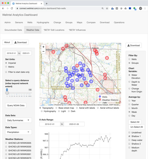
Wellntel’s Analytics Dashboard (AD) is aliving library of interactive tools to see water network behaviors andinteractions in real-time, creating powerful new insighst for managers andconsultants. 

The AD evolves based on direct subscriberfeedback. Designed with a familiar, browser-style tab interface, it allows youto explore your water data from every angle:
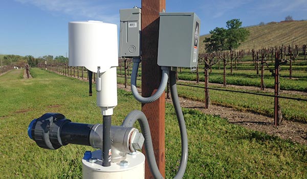
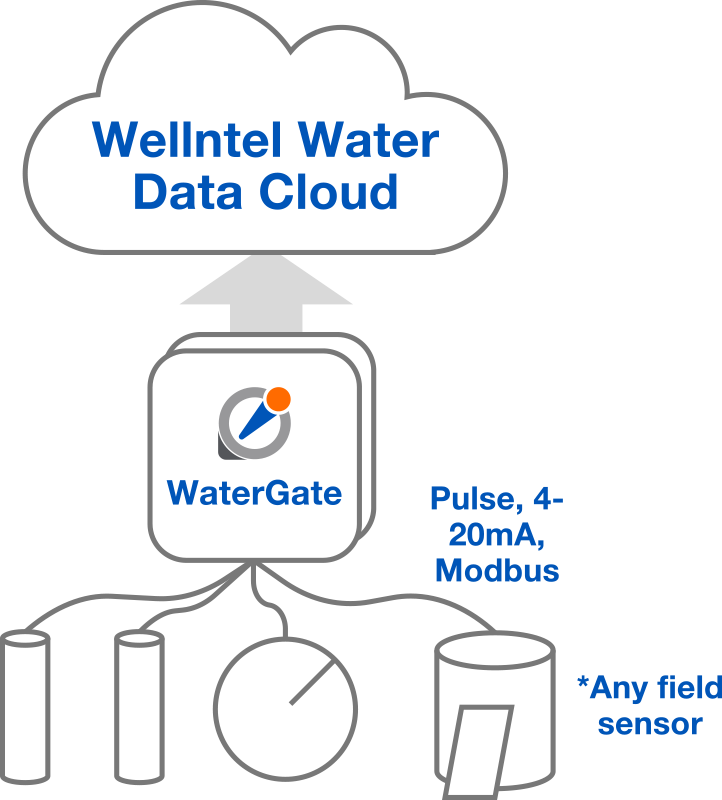
Centralize & Secure Your Data

  • Consolidate All Metrics: Store water levels, flow, quality, and precipitation (or any of a long list of other data types) in one central, time-series database.
  • Access Anywhere: Use custom-formatted APIs and CSV downloads for flexible data integration and offline analysis.
  • Maintain System Health: Receive weekly sensor health summaries to ensure your network is always online and reporting accurately.

Automate Your Insights

  • Identify Trends Instantly: Use the dashboard to see where and when deeper analysis is needed without digging through raw files.
  • Leverage Public Datasets: Integrate public data from USGS or NOAA to map gradients and visualize water supply flow.
  • Deploy Smart Alerts: Set up instant email notifications for specific wells or regions to protect assets and react to changes immediately.
  • Schedule Custom Reports: Working with the Wellntel team, generate and send fully customized weekly or monthly reports to your team automatically.

Engage & Empower Stakeholders

  • Share Real-Time Progress: Integrate embeddable charts directly into your website to keep the public or clients informed.
  • Provide Private Access: Offer well owners their own private dashboards so they can track their local conditions and water use.
  • Build Community Support: Use clear, insightful data to help stakeholders understand their groundwater resources and promote sustainable habits.
WellnTel Analytics Dashboard Image

WaterGate

Wellntel’s WaterGate is a sensor-agnostic telemetry gateway designed to transform your field instruments into smart, cloud-connected assets. It connects to a wide array of sensors - including transducers, flow meters, and water-quality sondes - to pre-process, organize, and securely transmit your field data directly to the Wellntel WMS.

The WaterGate provides a seamless "Analog-to-Digital-to-Cloud" (A-D-C) workflow for field telemetry. It polls sensors using pulse, 4-20mA, or RS-485 Modbus protocols and digitizes the output into XML or JSON formats. Data is then securely pushed via HTTPS to the Wellntel Water Data Cloud API, where it undergoes pedigree confirmation and encrypted storage.

A plug-and-play telemetry gateway:

  • Sensor-agnostic: supports Modbus, digital and current (4-20mA) and common analog  local protocols, like pulse (count)
  • Factory keyed: public/private keyset secures data transmission
  • Ethernet communication: option to include cellular modem where local internet is not available (fees apply.)
  • NEMA 4: waterproof, dustproof, tamper-proof locking enclosure
  • Power options: can be powered by local mains (AC 110/220 power), local 12/24V DC or included with rechargeable solar powered, battery-backed DC power supply.
  • Networkable: (up to 1:4 gateway to sensor ratio)
  • Hardened packaging: designed to be mounted outdoors and survive extreme weather. All cabling is self contained. Meets local electrical requirements/codes.
  • Remotely managed: health and data transmission status monitored via Wellntel Water Data Cloud.
Our gateway is designed to retrofit existing Wellntel Cellular Base Stations. By integrating a WaterGate into your current setup, you can leverage your existing communication and power infrastructure to support additional in-situ analog sensors.

Compatibility depends on the enclosure's available space for additional hardware, including wiring, communication modules, and network hubs. Our team can help determine the best fit for your specific equipment configuration.

Whether you are using legacy sensors or modern probes, the WaterGate transforms raw field data into actionable, real-time intelligence.
Wellntel WaterGate Diagram

WaterDrop

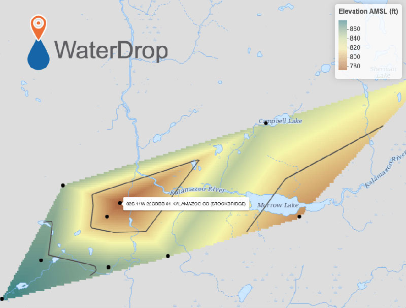
Built on our powerful cloud Wellntel WMS platform, WaterDrop is a free, public-facing dashboard to explore water dataanywhere in the U.S., or study water balance and build a sustainability plan where you live. With WaterDrop, you can track water inputs such as rainfall, snowfall and streamflow, monitor the condition of your water supply - including groundwater levels and reserves - and, with careful analysis, begin to understand gradients and flow patterns, showing where the water moves.

You’ll also see trends over time, spot patterns that deserve local attention, and start to quantify risk and opportunity. Areas where available data are insufficient will become clear, and with that confirmed data sparsity, you, your clients, and constituents can decide to invest to know more.

What does WaterDrop cost & how do I sign up?

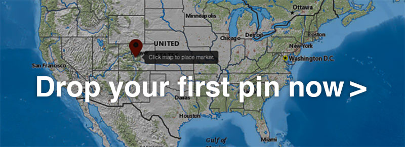
Visitors are welcome to try out WaterDrop. The “Basic” version is free, requires no login, and assembles data from:
  1. The National Oceanic and Atmospheric Administration (NOAA) NCDC Weather Stations
  2. The United States Geological Survey (USGS) NWIS network sensors
  3. USGS stream gauge flow sensors
  4. Available state databases
Wellntel Analytics Dashboard (AD) subscribers can also load these trusted public data sources alongside their own networks (or anywhere else) on maps, charts, and reports to share with colleagues and stakeholders.
Try WaterDrop for free today!
Interface of WaterDrop
Linked iImage of Water Drop Interface asking you to drop your first pin
“Wellntel fills an important monitoring role for us. The easy-to-deploy systems are designed for domestic style wells. For these applications, we prefer Wellntel.”
– Tim Ireland, SCADA Operations Manager, Yolo County Flood Control & Water Conservation District
+1 844-WELLH2Ohello@wellntel.com
906 E Hamilton St
Milwaukee, WI 53202
Sign up for our latest technology, installation & event updates!
© 2025 All Rights Reserved.
Privacy Policy Terms of Use